A big snowstorm is usually cause for celebration among winter backcountry adventurers, but under certain conditions, lots of snow can also bring lots of peril.
Avalanche fatalities in the United States have increased dramatically since about 2000, when the advent of more versatile ski, snowboard and snowmobile gear made backcountry travel more accessible to the masses.
Indeed, avalanche experts with the Bridger-Teton National Forest (BTNF) in western Wyoming have recorded 30 avalanche fatalities in the past eight years, compared with only 13 avalanche deaths recorded for the entire decade starting in 1990. Most of those deaths occurred in or near the Teton Range.
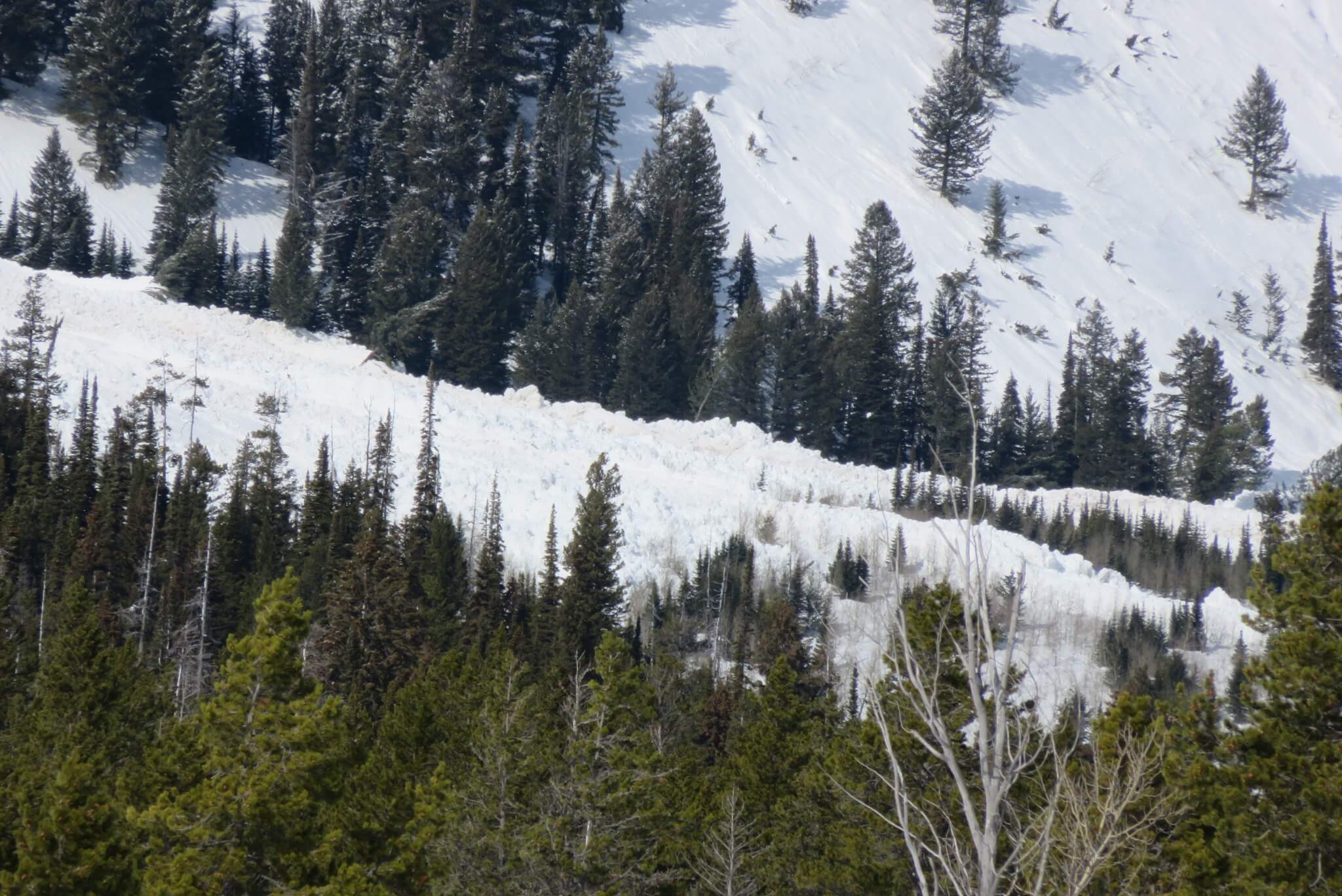
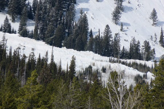
Recently, former Idaho National Laboratory intern Danielle Barna joined with the BTNF Avalanche Center to learn more about the science of avalanches by using satellites to detect a slide on Teewinot Mountain in Grand Teton National Park.
The research could someday provide snow scientists with valuable data to better predict dangerous avalanche conditions.
Barna, who is currently a junior at the Colorado School of Mines studying mathematics and statistics, first started at INL as a student intern from Skyline High School in Idaho Falls. For her senior project, she produced a hydrogeology report on the Norris Geyser Basin in Yellowstone National Park.
During the summer of 2016, Barna returned as an intern to INL, where she conducted a statistical analysis for the lab’s Partnerships, Engagement and Technology Deployment directorate.
And, last summer, she interned at INL again, this time to build a computer program that can analyze the kinetics of a catalytic reaction.
Barna’s avalanche project arose from her love of backcountry skiing. “I’ve been skiing since I was a little kid, and three years ago I started to get into backcountry skiing,” she said. “I realized there was some cool scientific literature out there on snowpack and avalanches and started to get really interested in the scientific side of the sport.”
Snow scientists at the Bridger-Teton National Forest and elsewhere analyze a number of different factors—temperature, elevation, snowfall amount, wind speed, slope angle and aspect, to name just a few—when making each day’s avalanche forecast. (To see an example of an avalanche forecast, visit http://www.jhavalanche.org/viewTeton. Change the date at the bottom of the page to view past avalanche forecasts.)
“The number of factors that go into avalanche forecasting makes it a great field for applying machine learning techniques,” Barna said. “When I had the opportunity to use a grant from my school, I jumped at it and asked the Bridger-Teton Avalanche Center if I could come work with them.”
Barna initially set out to conduct a statistical analysis that would correlate avalanche factors with avalanche danger, but she realized there simply isn’t enough data. Barna decided to reach out to her INL mentors for help.
The problem is that existing avalanche data mostly consists of observations from the ground. As a result, avalanche data is skewed toward avalanches that are easy to spot and those that occur in good weather.
Many avalanches, especially naturally triggered avalanches deep in the backcountry, likely go undetected.
To find these missing avalanches, Barna began looking into whether satellites could help. Her search led to a group of researchers in Norway who developed an algorithm that can detect avalanches from Synthetic Aperture Radar (SAR) images.
As the satellite crosses over its target, SAR creates a composite three-dimensional image from a series of radar pulses.
“After sifting through the literature, talking to people, and realizing this could be a viable project, I reached out to the Copernicus Snow Monitoring Project in Tromso, Norway, to ask how they were applying SAR imaging to avalanche sensing,” Barna said.
The researchers at Tromso had used specialized software to process images so they could manually detect avalanche debris.
At the Bridger-Teton National Forest, Barna and avalanche forecaster Dr. Chris McCollister decided to apply a similar technique to the Tetons using images from two European Space Agency satellites: Sentinel 1A and 1B (S1A and S1B).
S1A and S1B cross over the Tetons every 12 days, but because of the mountain range’s high latitude and the wide swath of the earth captured by the satellites’ sensors, Barna was able to collect images every one to four days.
The Sentinel data is free of charge, but the system’s relatively low resolution (5 meters by 20 meters) only allowed for the detection of medium to large avalanches.
Once Barna and McCollister identified the storm cycle they were interested in, they downloaded two images, one from before the storm and one from after.
The images were then processed and georeferenced before they compared the images with one another to look for differences.
“Chris McCollister and I looked through the images using a GIS program and detected the large Teewinot slide,” Barna said.
Barna’s mentors at INL say it’s no surprise that she’s experimenting with cutting-edge technology.
In fact, her most recent project at INL resulted in a minor breakthrough in the catalysis field, said one of Barna’s mentors, INL data scientist Ross Kunz. “She was able to implement a theoretical algorithm that allowed you to break down the kinetics of the reaction,” he said. “It helps quantify the search for a better catalyst.”
INL helped Barna take the math and computer skills she learned at school and apply them in the real world, said Dr. Tammie Borders, INL department manager for Data and Software Sciences.
Barna credited Borders and other INL researchers with providing valuable advice as she began learning about satellite imagery for the avalanche project.
“INL actually introduced me to satellite imaging,” Barna said. “Thanks to my internships at INL, I had the connections I needed with researchers there to gain SAR domain knowledge.”
Borders said she and other INL researchers involved with internship programs feel a responsibility to assist interns like Barna as they progress through their careers. “She knows she can reach back to us and we’re going to help her,” Borders said.
INL’s internship program provides students with the opportunity to apply what they learned in the classroom and gain work experience in a professional job setting. Interns bring new perspectives, increase productivity and enable INL researchers to identify future employees and collaborators. Learn more at inl.gov/intern.